
Archaeology is often imagined as a discipline of trowels, brushes, and painstaking excavation. While those traditional methods remain central, modern technology has given archaeologists new ways to uncover the past without disturbing a single stone. Among these tools, Ground Penetrating Radar (GPR) stands out as one of the most transformative. By sending radar waves into the ground and interpreting the reflections, archaeologists can "see" beneath the surface, revealing hidden structures, artifacts, and landscapes.
This article explores how GPR works, its role in archaeological research, the benefits and limitations of the method, and real-world examples of how it is reshaping our understanding of history.
1. What is Ground Penetrating Radar?
Ground Penetrating Radar is a non-invasive geophysical method used to detect and map subsurface features. It works by transmitting short pulses of high-frequency radio waves into the ground through an antenna. When these waves encounter a boundary between materials with different electrical properties — for example, soil and stone — part of the wave reflects back to the surface, where a receiver records it.
The time it takes for the radar waves to return and the strength of the signal provide clues about the depth, shape, and composition of buried objects or layers. By moving the radar system systematically across an area, researchers can produce detailed images or “maps” of the subsurface.
2. Why GPR Matters in Archaeology
The allure of GPR archaeology often lies in discovery — finding the remains of past cultures that have long been hidden. However, traditional excavation can be time-consuming, costly, and destructive. Every excavation site is altered forever, and archaeologists must make careful choices about where and how to dig.
GPR changes this equation by offering:
Non-destructive exploration: Sites remain intact, allowing for future research with improved technology.
Efficient surveying: Large areas can be examined relatively quickly compared to manual excavation.
Targeted excavation: Researchers can focus on the most promising areas, reducing unnecessary disturbance.
Preservation of fragile sites: In locations where digging could harm the integrity of remains, GPR offers a safer alternative.
3. How GPR Works in Practice
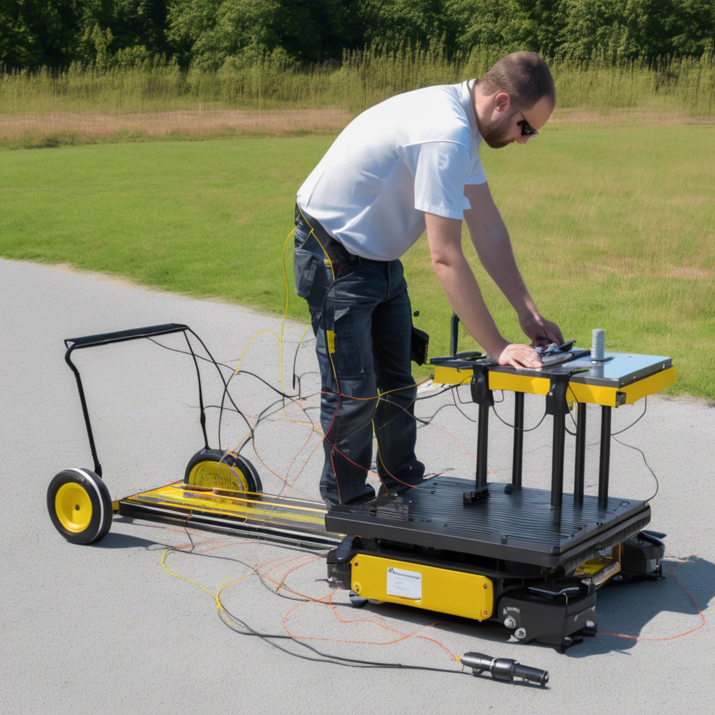
a) Data Collection
The GPR unit is typically moved along the ground in parallel lines, much like mowing a lawn. Each pass collects a “slice” of subsurface data.
b) Signal Interpretation
The recorded reflections are displayed as waveforms or converted into two-dimensional profiles showing depth and shape. Modern processing techniques allow these profiles to be assembled into three-dimensional reconstructions of buried features.
c) Identifying Features
Different materials reflect radar waves differently. For instance:
Stone walls often produce strong, continuous reflections.
Voids, like tombs or tunnels, may appear as hyperbolic shapes in radar profiles.
Disturbed soil can indicate previous human activity.
4. Applications of GPR in Archaeology
The flexibility of GPR makes it useful in a wide variety of archaeological contexts.
a) Mapping Ancient Structures
GPR can reveal the foundations of buildings, roads, and other infrastructure without excavation. In some cases, entire ancient city layouts have been mapped in this way.
b) Locating Burial Sites
Burials often leave distinct radar signatures, whether due to the grave shaft, coffin materials, or skeletal remains. This allows archaeologists to locate cemeteries without disturbing the graves.
c) Tracking Changes Over Time
By examining soil layers, GPR can help reconstruct the sequence of occupation, flooding events, or construction phases at a site.
d) Underwater and Wetland Archaeology
In certain conditions, GPR can even be adapted for use in shallow water or wetland environments, detecting submerged artifacts and structures.
e) Surveying Sensitive Cultural Sites
Some locations are considered too culturally sensitive for excavation. GPR enables research while respecting the wishes of descendant communities.
5. Advantages of GPR in Archaeology
High Resolution: GPR can detect small features, often just a few centimeters in size.
Depth Penetration: Depending on soil conditions and frequency used, GPR can reach depths from less than a meter to several meters.
Adaptability: Works in various environments, including urban areas where excavation might be impossible.
Real-Time Results: Field operators can often identify promising features as they collect the data.
6. Limitations and Challenges
While GPR is a powerful tool, it is not without its challenges.
a) Soil Conditions
Certain soils, especially those rich in clay or salts, can absorb radar energy, reducing penetration and clarity. Sandy or dry soils typically produce better results.
b) Interpretation Complexity
GPR data require skilled interpretation. Natural features like tree roots or rocks can produce signals similar to archaeological remains.
c) Cost and Equipment
GPR systems can be expensive, and fieldwork may require trained operators. However, the cost is often offset by the efficiency and preservation benefits.
d) Limited Depth vs. Resolution
Higher-frequency antennas produce sharper images but penetrate less deeply, while lower frequencies reach greater depths with less detail.
7. How GPR Data is Presented
GPR results can be displayed in different formats:
Radargrams: Vertical profiles showing depth vs. horizontal position along each survey line.
Time Slices: Horizontal “slices” at specific depths, allowing archaeologists to view the plan of buried features.
3D Models: Layered data assembled to create volumetric images of the site.
These visualizations allow researchers to “peel back” layers virtually, examining each stratum in sequence.
8. Examples of Archaeological Discoveries Using GPR
While names and locations vary, GPR has contributed to a wide range of finds:
Mapping the outlines of ancient temples buried beneath agricultural land.
Discovering networks of tunnels and chambers under historic fortresses.
Revealing the layouts of long-lost settlements hidden beneath modern cities.
Identifying shipwreck remains buried in sediment.
These discoveries often spark renewed interest in sites previously thought to be fully explored.
9. Ethical Considerations
The non-invasive nature of GPR does not mean it is free from ethical concerns. Archaeologists must still consider:
Cultural sensitivity: Some communities may object to even remote sensing of burial sites.
Data sharing: Maps of buried features may require protection to prevent looting.
Interpretation transparency: Clear documentation of methods ensures findings are trustworthy.
10. The Future of GPR in Archaeology
GPR technology is advancing rapidly:
Improved antennas are extending depth and resolution.
Automated analysis using artificial intelligence is speeding up data interpretation.
Integration with other methods, such as magnetometry or lidar, produces richer, more accurate site maps.
Portable and drone-mounted GPR units could make surveying faster and more accessible, especially in remote locations.
As technology evolves, archaeologists will be able to conduct more extensive surveys with less disruption, uncovering patterns and structures invisible to the naked eye.
11. Conclusion: A Bridge Between Past and Present
Ground Penetrating Radar is revolutionizing archaeology by giving researchers a way to explore hidden worlds without turning a spade. It preserves the integrity of sites for future study while allowing present-day archaeologists to make groundbreaking discoveries. By combining ancient curiosity with modern science, GPR bridges the gap between past and present, helping humanity unlock the stories buried just beneath our feet.
In an era when preserving heritage is as important as discovering it, GPR offers a path forward — one that respects the past while embracing the tools of the future. From ancient cities to unmarked graves, this technology ensures that history is not only found, but also protected for generations to come.


Write a comment ...